0 Comments
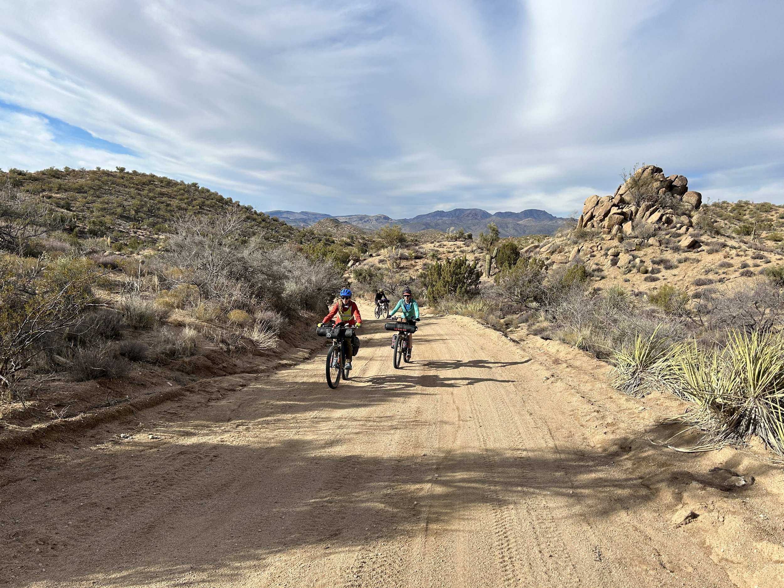
Tres Rios Loop - Day 3 - Around the Arrastra Mountain Wilderness and Across the Bill Williams River1/14/2024 52.76 Miles; 6,936 Feet of Gain; Alamo Lake State Park to Signal Road In the early hours of morning I hear Kate's alarm on her phone go off. I know it went off, but all I want to do in the morning cold/darkness of winter is curl up in my quilt and keep on sleeping. But, I know we need to move because today could involve some route-finding that might eat up some hours. So, it is time to move. Winter means dark mornings and today was no exception. I roll around in my quilt before I find the onus to get up and get moving in the dark. It certainly isn't as cold as yesterday morning. The desert morning brings soft, diffuse light that brightens pinkly on the craggy hillsides around us. Alamo Lake appears in the distance. All the bikes are packed and we pedal over to the side of the little general store to fill our waters from the outside hose spigot.
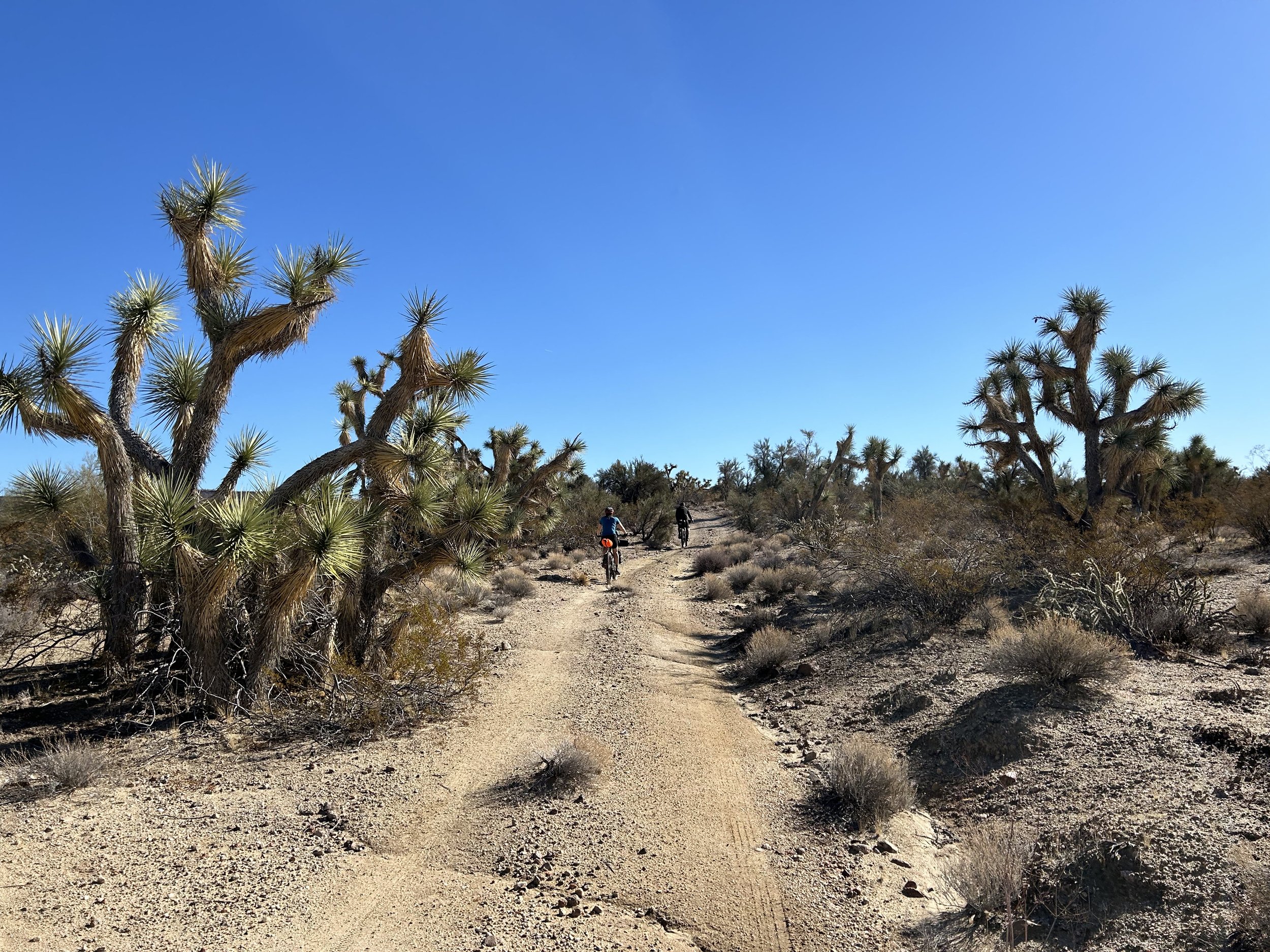
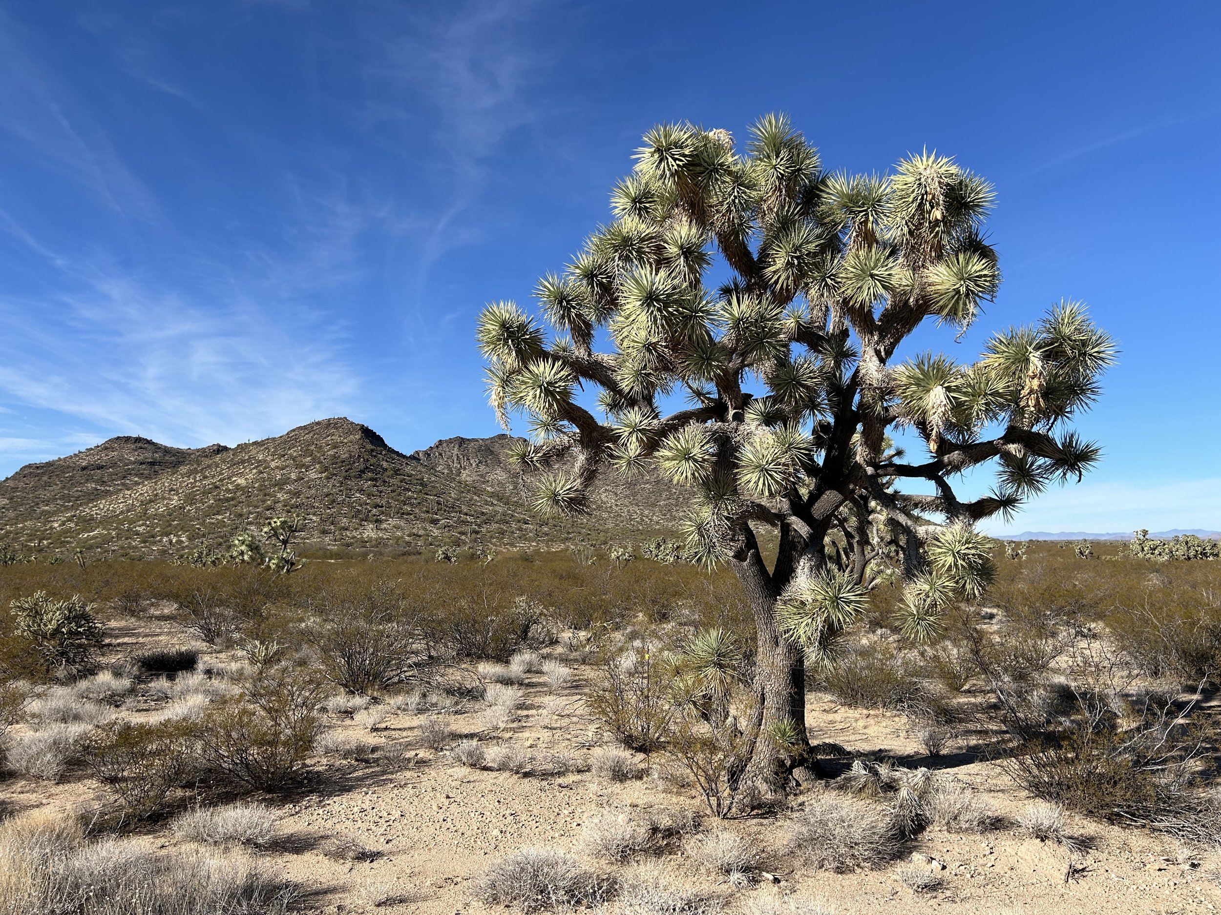
 As light crept over the land bringing some slight warmth, the four us start cycling along the pavement out of Alamo Lake State Park and back towards Wayside. We regroup at the restaurant intersection back along the massive dirt highway of Wickenburg Road. It's north from here on a slightly gaining downhill as Alamo Lake looms large set along the foreground of the Arrastra Mountain peaks. I'm excited, yet nervous given the previous days' route-finding, about what navigating a crossing of the Bill Williams River might look like. Bushwhacking? Lots of water? Lots of sand? The route notes indicate the area is usually a trickle. But with the recent snowstorm and water in the Santa Maria, I'm feeling sure that we'll have some significant water to come. Wickenburg Road turns off onto Brown's Crossing Road (a good indicator of what's to come). The road transitions from wide dirt to brittle doubletrack traipsing across desert volcanic gravel. We enter a thicket of tamarisk while a row of fall-foliage cottonwood thickly rise out of the northern banks of the reservoir. I'm absolutely loving the red-rust rock and crumbly orange hues of dirt that skip to white powder back and forth. The Arrastra Mountains are stellar looking ahead. It's one more switchback down a cliff and into a riparian thicket that turns out onto a sandbar. The confluence of the Big Sandy, Santa Maria, and Bill Williams Rivers means the water is no trickle today. There's a steady and big stream - probably 50 feet across with little sandbar islands for us to pass. We leave our bikes and begin walking up and down the embankment looking for the most viable/dry crossing. There's some big holes in that stream - dark and blue with bottoms not to be seen. We can see an obvious ATV route that crosses the river while working around the truly deep parts. I start laughing and just embrace the moment. I hoist my bikepacking rig on my shoulder and just plunge into the stream to get to cross to the other side. The water is warmer than I think. I love it. I head back to help Janna take her bike across (given her back).. The four of us make it across, and I'm stoked on the ride to come today. I bike ahead down DEEP sand in the heart of the river wash while the stream flows to my left. Janna, Kate, and Dan eventually come riding up after getting their socks/shoes back on, and we're off heading down more packed sand along the literal edge of the Arrastra Mountain Wilderness before a quick turn on a road takes us up onto reliable firmament. We climb out of the reed-lands of the riparian onto colorful and crumbly mountain rock. An abandoned bus top sits rusting in the sun. The desert winter day is quickly warming. I'm just full of energy and excitement at this adventure. The ATV road is really a rolling-lolling track that goes up and down washes and punchy climbs through desert rock along the northern perimeter of Alamo Lake. We do quite a bit of hike-a-bike, but I'm soaking it all in just absorbing the warmth and views. Lunch arrives with midday Sun embracing the land. We stop and eat amongst the landscape gravel while groups of ATVs out for the weekend pass us along the doubletrack. We've covered miles, but all of our GPS watches indicate we've done serious up-and-down climbing along that ATV road several thousand feet more than either Strava or RWPGS have indicated. I'm optimistic that the day's elevation majority is behind us; Kate looks ahead at the elevation profile and says the lion's share is to come. I accept it, just absorbing all the desert has to offer in this area. We pack up lunch and continue along the ATV road that turns north and away from Alamo Lake. Now called Alamo Road, the climb becomes that classic Arizona-chunk: an old mining road crumbling with babyheads, granite spates, and thick gravel that sinks and slips. We reach the top of a pass after some granny gears and bike-pushing. I'm alive and energized, but the four of us most certainly are sweaty and hot, all cold-acclimatized from our northern homes. I eat some snacks and drink a ton of water. We round a corner in the pass and suddenly Artillery Peak is gorgeously rising as a volcanic heart out of the desert folds. It looks contrasting and unreal. I jaw-drop to snap photos. Maybe it's just me, but standing on that dirt pass looking over arid plains with the mountain rising up made me feel like I was in the arid upper-stories of the South American Andes. The ride towards and around Artillery Peak was a highlight of the route and of the day. Alamo Road meanders up and down the tumbling base of Artillery before it sinks into a wash. The wash becomes a sand basin. It is a sizable climb, uphill, with fine grit-sand that wheels sink deeply in. Dan and I continue in our smallest gears to climb up the wash. Janna and Kate, more strategically (and at equal speeds to us), disembark and simply walk their bikes for the several miles of sand-uphill. Saguaros and Joshua trees intermingle once more - Mojave and Sonoran. I punch my way finally up and out of the sand to the saddle between Madrill Peak on my right and Eagle Point on my left. Before us spreads wide-basinlands punctuated by desert ranges. It is stunning in the later-afternoon sun as the four of us stare at a rewarding downhill. Dan and I let loose. Exhilarating descent takes us into a dense jungle of spikey Joshua trees covering every foot of desert floor. And just like that we are off of Alamo Road and onto Signal Road. Signal is a true dirt highway wide and smooth. I'm absolutely alive descending it with ease amid the day's waning light that winter bends to golden. Joshua trees give way to creosote. We're tired at this point - the day's ride longer and the elevation gain so much more than predicted by our cycling apps. Mile markers tick past. For some reason, I have it in my head that the cars are parked at mile marker 12. That is, until we pass 12. I decide it is 14. 14 passes. Absolutely has to be 16. Until we pass that too under gathering dark. Our track elevation suggests a big climb to come and we certainly haven't hit it. I start just laughing at how exhausted and endless these last miles feel. Laughing is always a respite from circumstance; that always energizes me. I fill with motivation and an abiding sense of appreciation for the beautiful desert we're crossing. The four of take a rest at the crossing of Big Sandy River (truly sandy) before deciding to muster the energy to continue forth to the end. Darkness and desert glow give way to black of night. Janna and I push forward keeping our go-all-day-don't-stop pace as the last climb gathers under our tread and we slow to a crawl. The crawl becomes a hike-a-bike upwards. I look back out into the night and see Dan and Kate's lights below us shining at the foot of the climb - sole illumination across the vast desert dark. It's a couple of miles and hundred of feet later that I see the distant moving headlights of the highway. I know our cars are close. I'm thankful for the relatively warm temperatures as we finally pull off into the side-area where our cars are parked on BLM land. Instantly, Janna and I rip out food wherein, shortly thereafter, Dan and Kate join us. The four of us dump snacks and food into a circle in the dirt. We sit, laughing at how much harder that was than we anticipated (7000 ft. of gain today). But also super grateful to be out here seeing a beautiful and different part of Arizona than any of us had been to before. There's some talk of maybe camping here, but Janna and I have work for school we need to get done for tomorrow, so the four us head back to the Canyon, not getting back until well after midnight after stopping at a gas station for more snacks along the way. 51.4 Miles; 2,602 Feet of Gain; Santa Maria River to Alamo Lake State Park 
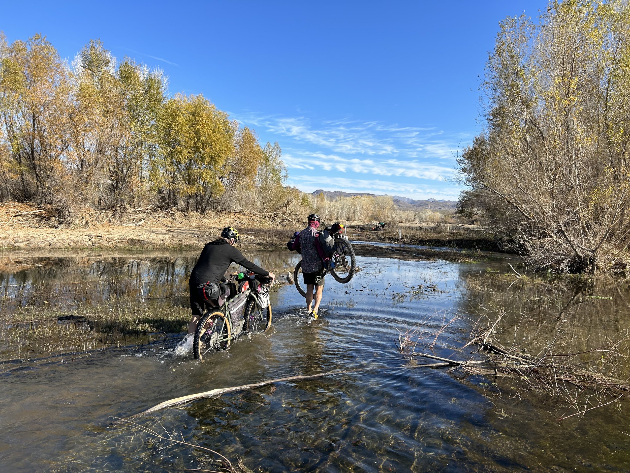
Last night was the cold call of winter desert. The wash, rich with atmospheric moisture along the Santa Maria River, saturated our shelters with condensation that iced a quarter thick both interiorly and exteriorly. I wake up to pee in the night and feel my the top of my head scrape crystals from the inner walls. With dawn's cusp, we stagger into the diffuse light. Janna and I's bikes are caked in a quarter inch layer of soup frost - probably the thickest I've ever seen outside the Sierra Nevada. The frost is copious. It's probably somewhere in the mid-teens temperature-wise so we're all moving around slowly trying to keep fingers warm while simultaneously performing camp tasks. No one is too excited for the prospect of morning water crossings down the wash in these conditions. Janna heads off to do her morning business far from the water and scampers up the cactus-crusted hillside that banks into the streambed. I head over to the Santa Maria River where a steady unfrozen flow bends near camp; I want to get my day's water purified so I can use water for breakfast. The water is warm compared to the air, so it doesn't feel too unpleasant to get my hydration bags filled. Janna comes back and announces to the group that she found an old mining road rising from the river wash literally directly adjacent to our camp. Dan goes up to do his business and to check it out. Kate and I pull out RWPGS and Gaia GPS to zoom in and figure out if this road could possibly be our route, or whether we need to bushwhack further downstream. The contour lines are tight and the road so close to the river that it's hard to say. I've got water done and start dismantling the ice-shelter with Janna. We shake as much frost and ice off of it as possible but it's going into the saddlebag wet. Same with our sleeping bags that have a solid sheen of frozen water coating them. I make a mental note to pull them out later today when it warms up around lunch to dry while we eat. Dan comes back and confirms the road. By this point I've eaten and packed up, so it's my turn to go do my business. I tell everyone I'm going to head up the road for a bit to see if the GPX track overlays well with it. As soon as I'm up above the wash on the road, the morning sun hits me and brings strong warmth. After trekking for a bit I stop and find a nice wide plain to do my business. I also confirm this is definitely the route so no more riverbed hike-a-biking for us. I also make a note that there is a huge plain of desert up here that would have been awesome to camp in above the low wash below. Feeling assured, I make my back to camp where everyone is finishing up water-filling and packing up. We all agree that hill is the way. The luck that we camped near its base has us laughing. And then it's up and into the morning sun now warmer than yesterday and striking frost from the face of everything. The road continues along the edge of the Santa Maria River, carving a path through the desert canyon below and absolutely stunning in the daytime. Our route takes a turn away from the river to head south. The Santa Maria continues its flow west into the heart of the Arrastra Mountain Wilderness which rise large, crumpled, and desert-awesome before us. It is only a few miles later that large saguaros dotting the route become accompanied by a thickening number of large Joshua trees. Sonoran crashing with Mojave. Just absolutely everything that I love about living in Arizona. I keep stopping along the two-track to take photo after photo of saguaros growing in the foreground of the Arrastras or jumbles of J-trees crooked and casting shadows in the winter slanted light. The two track continues before merging with a sand-filled wash where speeds slow. But it is short-lived as the road climbs up into a density of Joshua trees that stretch out in every direction. We continue through the Joshua tree forest before slowly merging with a lower powerline road that crosscut across the landscape, parallel to Highway 93. Our speed feels slow for the day, all of us feeling winter-fatigued with the push from yesterday. By 2 pm, we have covered only 15-something miles with our party-pace, frequent snacks, and stopping for photos. At a nice hill climb along the powerline towers, we stop to prop our bikes and sit out in the sun for a late lunch. I take the opportunity to hang our shelter and my quilt from the side of one of the towers to catch that mid-day sun and warmth (wanting them dry). To our rights, the Tres Alamos Wilderness and corresponding peak rise up across the Joshua tree plains. Gear dried and stomachs full, we push on only to stop a mile later to talk to a guy in an ATV with a flat tire. He is absolutely blown away we were out here and asks us a ton of a questions about how we could possibly be coming from the direction we are coming. It turns out he winters every year out here and loves it. He wishes us well, says he was good with his tire, and we continue along the powerline road. A mile or two later brings intersection with the official start of the route with a righthand turn onto Alamo Road. And what a road! It is wide, smooth hero dirt - the stuff of gravel riding dreams. Alamo Road also cuts a westward track across the desert almost completely gradually downhill making our progress quicken both for terrain and for elevation loss. Our pace improves and shoots us straight getting miles accumulated quickly. We laugh and take pictures of our group as Joshua trees frame the adjoining peaks to our rights. The road keeps sliding downward and we with it as caravans of ATVs began passing us - making their way to the lake or public lands for boondocking and weekend escapes. Everyone is polite and amused to see cyclists out there. The miles came easy and by just before 5, we've already covered 45 total. We roll up to Wayside Bar and Grill, sitting dusty in the desert, and the group choice is unanimous: time for some hot food now that the cold is descending again. We prop our bikes and go inside to grab some tater tots, chicken strips, and chips/salsa. The locals come to talk to us, one guy saying we were amazing and hardcore to be riding out here. The vibe is welcoming and the food hits that salty-hot spot for the palate. But we know evening is coming on fast, and we are planning to go over six miles off-route to stay at Alamo Lake State Park that night. We head back out to our bikes and put on warm clothing. Overhead, a sunset is ripping beauty and colors across the sky. The four of us head down Park Road under gathering twilight. The colors are everything I love about living in the Southwest - blurred blues and wispy grays sauntering with oranges and streaked reds while stars twinkle above. That portion of the day's ride is amazing under desert-glow skies. As night takes over, we join pavement and ride into Alamo Lake State Park under darkness. Luckily, as compared to the night before, the conditions here are relatively warm (above freezing) and absolutely dry. We setup camp and get to work eating dinner. I feel so relaxed. There's a calm of appreciation that comes from ideal camp conditions and this is it. On top of that, we have much of the campground to ourselves. The bathrooms have showers and ample hot water (plus they are clean). Water is a little more difficult to find. Heads up to cyclists: there's a spigot on the side of the Camp Store building if you're looking for water. Once we get camp settled and stomachs fed, we all go to bed knowing tomorrow might involve some bushwhacking once more to get around Alamo Lake. All night long, wild burros wander near/around the campground screeching. I love it.
36.8 Miles; 4,134 Feet of Gain; Signal Road outside Wikieup, AZ to the Santa Maria River
January is always the middle of winter here on the South Rim. And the craving for desert warmth and escape always hits true. When Janna and I were looking ahead to the MLK, Jr. holiday weekend, we decided to travel with Dan and Kate, who were scheduled for furlough and were going to be down in Arizona from Glacier NP at that time. The four of us wanted to catch up, and we felt a bikepacking trip through the desert deserved merit for an adventure all together. At first, we were looking at creating a route through Gold Butte NM, but we all felt a closer, warmer, and shorter route would be preferable since none of us had ridden much due to winter. At the beginning of December, Kurt Refsnider published his Tres Rios Loop.
Tres Rios is a southwestern desert bikepacking route located in west-central Arizona. It does a big circumference of the Arrastra Mountain Wilderness and weaves by the Tres Alamos, Rawhide Mountains, and Upper Burro Creek Wildernesses. It's name derives from the three main rivers it crosses: the Santa Maria, Big Sandy, and Bill Williams. Subsequently, it wraps around Alamo Lake where these rivers end at reservoir. And most excitingly, it travels through a unique region where three ecosystems merge: the Colorado Plateau, the Sonoran Desert, and the Mojave Desert. As a result, there are multiple instances on the route where juniper trees, saguaro cacti, and Joshua trees grow side-by-side - a rare thing to see! I started pouring over the RWGPS route leading up to the trip. Although Kurt called for starting at the very southeastern portion of the route, I decided to have us park/start on BLM land up at the very northern part a mile west down Signal Road right off Highway 93. The advantages to us were a resupply mid-trip at Alamo Lake/Wayside (as opposed to riding by these Day 1) and less driving for us coming from the Grand Canyon. The two days prior to the start of the trip, a massive snowstorm came dropping loads of winter precipitation across the state. Snow levels fell to around 3500 feet (which corresponded to the highest touches of the route). Even lower portions in the desert received solid rain. On top of that, a plummet of temperatures meant state-wide frigid temperatures. The four of us woke up at 5 am on Friday and caravanned to our starting point (with a pause in Williams for coffee).
By the time we arrived, the outside temperatures were 28 degrees F - a chilly start for a desert ride. We put our bikes together and just sat absorbing the sun. And then we pushed off just before 10 am. Signal Road turned out to be the best of hero dirt. It was wide, well-graded, and smooth as silk - one of the rare dirt roads in Arizona where I would consider riding a skinny-tired gravel bike (much of the rest of the trip was on rutted dirt roads and copious sand - so bring that mountain bike!). We had a lot of uphill planned for day 1 which didn't disappoint. We passed by Elephant Mountain on a beautiful climb with some hike-a-bike for us with winter-fatigued legs. Along a side-canyon, juniper trees fecund with pale-blue seed popped up along with crown-of-thorn plants. And then saguaros - growing in nurse trees of juniper! Freaking awesome. Dan's a plant biologist and kept stopping to talk about the diversity of plant life and the unusual spread of species growing together.
The route descended a bit before wrapping through more rocklands with saguaros and junipers but now yuccas with old-pale blooms and ocotillos galore. Red Knob appeared ahead and we stopped to take it in from a distant vantage. Then it was some climbing up to the intersection of Sycamore Camp and Burro Creek Crossing roads. We laid the bike downs and listened to a large herd of wild burros down a drainage next to us calling and screaming. There were so many wild burros along the route - though non-native, we found them super cool. The four of us ate lunch and soaked up the sun. Then began a large descent down to Burro Creek through the ecologically sensitive area of Clay Hills.
The winter storm had produced a nice flow and set of pools in Burro Creek. It was well-framed under barren winter-armed sycamores and cottonwoods. We continued out of the creek basin and up the road along Suicide Wash through a canyon. The sand on this section was serious. It quickly turned deep and fine. We all were sporting 2.6 - 2.8 inch tires, so we dropped to granny gears and started a slow uphill through the sand. Kate called out that there were very large, well-defined mountain lion tracks that were fresh in the sand. After looking at them (so cool!), we looked around knowing it was probably nearby watching us. Frequent burro tracks also dotted the sandy riffles.
The four of us began hike-a-biking through the deepest sand as pedaling became inefficient to the point that we were falling over. Suddenly, we popped out among a jumble of interesting sandstone rock pinnacles where we turned down a sandy and wide road cutting through a dense stand of junipers and yuccas. The temperature was beginning to drop, cutting just above freezing. The dirt road merged with paved 97 that then led us to Highway 93. We all put on our safety vests and turned on our back lights as it was late afternoon in winter and some high cloud cover was gently gathering in the sky reducing visibility. Luckily, the ride on the shoulder of Highway 93 was pretty fast. It was several miles of almost entirely fast downhill on a wide shoulder, despite heavy and fast traffic. What caught us off-guard was the next portion of the route.
Kate and I were staring at our GPS devices in anticipation of the turn that would take us off the highway, across a short stint on private land through a wash, and onto a dirt road on state land where we could legally camp. Except, we arrived at our turn and didn't see a dirt road. Instead, we zoomed in on the GPX track to realize that we were gong to need to dismount our bikes and do a bushwhack scramble down a hillside to avoid the private land. A bit surprised, we all helped each other life our heavy rigs over the railing on the side of the highway. Then, Kate and I went scout-scrambling down the thornscrub-choked hillside for the best way to get to the Santa Maria River wash. About 30 minutes later, with sunset fast approaching, we scrambled back up to the highway and led the group tenuously down the steep hillside through creosote, cholla, and brush to a level spot. Here, a large barbed wire fence separated us from the sandy river bottom. There was a significant lower gap at the barbed wire fence. We split into two teams: one team held on to the bottom of the fence to lift it as high as possible and the other team pushed/pulled the heavy bikepacking rigs under the fence.
Finally, we were on the floodplain of the Santa Maria River. We pedaled along an old vegetation-chocked doubletrack that decayed into brush where we got off and pushed our bikes through jumbles of mesquite, looking for the best way to the main sand-river-channel visible ahead. We made our way through another fence and started to push our bikes through riparian woodlands. It was hotly past sunset at this point with temperatures below freezing. The impetus was on to get through this hike-a-bike down the river channel to public land to setup camp. The sky became a spectacular splay of winter-desert colors. It was absolutely gorgeous. We turned on bike lights to lead the way as we wandered and wove down river-stone and through thickets of cottonwood brush. Due to the winter storm, the Santa Maria had a decent flow of water and some deep pools. At one point, we cliffed-out above a really deep/impassable hole of water where the river took a drop over boulders. We worked our way arduously around it and realized we had to cross the water once more. A strong smell hit our noses and we turned to see the huge rotting carcass of a dead cow lying on the bank and in the flow of water. Dan made a joke about us all getting tapeworm parasites, so we made distance from the cow to get downstream farther. As it was below freezing and already fast into darkness, we didn't want our shoes/socks to freeze by getting them wet at this hour. We all took off our socks and shoes and waded bikes across the river-stream. At some point, I stopped in the dark to check the "Private Land" layer on Gaia to confirm we were off private land. Luckily we were. It was past dark enough that no one wanted to bushwhack much further so we found a grassy embankment just above the river where we decided to setup camp. The temperature was really falling so we quickly setup camp, put on warm clothing, and set about making dinner in the night. I have a general backcountry rule never to camp near water and low to avoid cold spots and condensation. Tonight would encompass both of these. As soon as dinner was finished, we crawled into our tents, tired and ready for sleep. |