
Stagecoach 400
Table of Contents
2024
Stagecoach 400 - Day 1 - Alpine, Descanso, and the California Riding and Hiking Trail
Stagecoach 400 - Day 2 - Descending Oriflamme Canyon and Entering the Anza-Borrego Desert
Stagecoach 400 - Day 3 - Anza-Borrego State Park: Sand, Mud Caves, Fish Creek, and Borrego Springs
Stagecoach 400 - Day 4 - Coyote Canyon, The Willows, and the Climb to Idyllwild in a Winter Storm
Stagecoach 400 - Day 5 - Zero Day in Idyllwild, CA
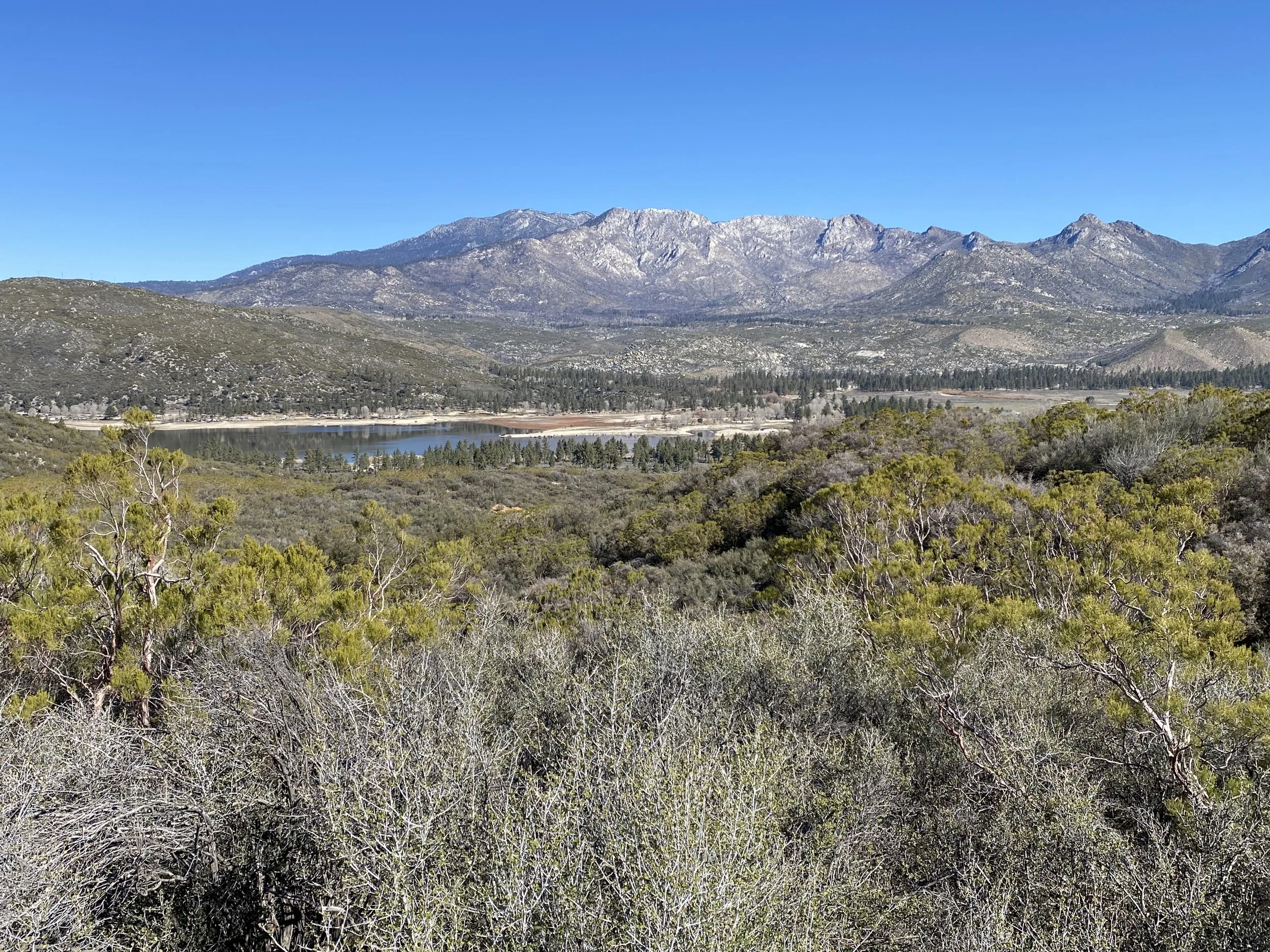
Stagecoach 400 - Day 6 - A Winter Storm at Our Backs to Anza and Lake Henshaw
Stagecoach 400 - Day 7 - Singletrack to San Diego along the Coast to Crest Trail
Stagecoach 400 - Day 8 - The Pacific Coast, San Diego National Wildlife Refuge, and Finish!
2022
Stagecoach 400 - Day 1 - Idyllwild and the San Jacinto Mountains
Stagecoach 400 - Day 2 - Coast to Crest Trail
Stagecoach 400 - Day 3 - Along the Pacific Coast Highway before inland through the San Diego National Wildlife Refuge
Stagecoach 400 - Day 4 - Zero Day at Vineyard Hacienda in Rancho San Diego, CA
Stagecoach 400 - Day 5 - Detour on the Stagecoach 400 to Explore San Diego

Stagecoach 400 - Day 8 - The Pacific Coast, San Diego National Wildlife Refuge, and Finish!
Sleep is deep and thorough, so that by the time we wake up, the soreness in our bones has been abated. Today is planned to be shorter both in elevation gain and distance compared to most of the previous days - which means one thing --> a slow morning to enjoy ourselves. It's also our last day which happens to coincide with a ride along the Pacific Coast. We hum with excitement and the promise of beautiful weather. I open up the blinds to our hotel room and gorgeous bluebird morning light spills in. Janna and I walk down to the complimentary hotel breakfast which sits in a partial-outdoor room. The air is fresh, maybe even crisp, with the saturation of moisture that soaks our lungs in relief. It's looking to be some of the best weather conditions of the trip - a perfect way to finish the Stagecoach 400. We eat, pack up, and push out right along the PCH bike lanes we've ridden so many times over the years on previous trips.

Stagecoach 400 - Day 7 - Singletrack to San Diego along the Coast to Crest Trail
I snuggle deep into my quilt during the night. I awake multiple times to the patter and then sheeting of precipitation shedding from the winter storm down on our shelter. Even a little thunder. Each time, I just snuggle into a deeper sleep and pass the hours away. Morning comes with a faded glimmer. Janna's up before me to use the restroom. She comes rushing back into the shelter to wake me up and says all the hillsides are caked in snow. I throw on my puffy and race out of the shelter to go see for myself. I walk to the front of the resort entrance and stare at an amalgamation of parting clouds, the entrails of the winter fury, sagging over the hills and peaks of the Beauty Mountain Wilderness. In their clearing I can see the mountains caked in snow. Everything we had ridden through yesterday between Anza and here is covered in white. It looks like the snowline ends about 100 feet above our current elevation below Black Mountain. Had we camped any higher up last night, we'd be waking up to several inches on our tent. I look up the weather and see Idyllwild got nearly 6 inches of snow last night, with another 5 inches predicted to fall starting today. I mentally note how lucky we were to get out of there when we did or we'd be snowed in.

Stagecoach 400 - Day 6 - A Winter Storm at Our Backs to Anza and Lake Henshaw
I'm buzzing with anticipation as soon as my eyes open. The room is warm, the bed welcoming, and my legs tired. But, I know the next round of Santa Ana Winds are brewing a concoction of snowstorms on high and thunderstorms down low. We dress at 5 am, eat breakfast, and flip on the TV. Sure enough, the local news is plastered with images from downtown LA where the Santa Ana Winds are ripping and roaring. Trees are shorn, stoplights whipped, and even cars crushed from falling debris. The news reports gusts of wind hitting 70 - 80 mph. Holy shit. We open the drapes and see nothing yet that strong outside our room at the Idyllwild Inn. Janna and I both put some substantial layers on as we prepare to exit into the cold. It's absolutely brooding outside, a mix of moody clouds and swirling gray that indicates the atmospheric instability overhead. We push past the door and down into the empty town of sleepy-morning Idyllwild where we are one of the few out. We had debated last night which route to take this morning. The official route descends off the mountain on dirt roads and singletrack. The alternate is to just ride the highway straight back down the way we came up which is shorter and faster. I've done the latter two years ago on this route (when the dirt descent was closed from wildfire damage); I'm hungry to see the official way down so we start the morning ascending through neighborhoods until we hit dirt and enter the San Bernadino National Forest.

Stagecoach 400 - Day 5 - Zero Day in Idyllwild, CA
Idyllwild is simply an ideal trail town for a zero day. The best trail towns are small, walkable, have access to everything a backcountry traveler needs including a full grocery, delicious restaurants, outdoor gear, and a place to lodge or camp. And all within a nominal distance for someone looking to take a day off their legs. Although the Stagecoach 400 is intended to start and end from Idyllwild, Janna and I planned our route this year to make it a mid-route stop with time for a zero day and resupply.

Stagecoach 400 - Day 4 - Coyote Canyon, The Willows, and the Climb to Idyllwild in a Winter Storm
The Santa Ana Winds are here. And they are powerful.
The night is a swirl of gusts and flapping fabric. The X-Mid holds secure - success born of its design and our campsite choice. But the winds just continue to grow throughout the night. I shove earplugs in deep to drown the sound of gusts whipping. The heat of the desert dies in the night; it's replaced by a chill from wind and storm front. I awake to use the restroom several times and tighten all guylines each time. But I sleep, and so does Janna. My eyes are already open when my alarm sounds at 5:30 am. The two of us decided to wake up extra early for several reasons: (a) today is the crux of the route with The Willows, (b) today will also hold the most elevation gain per our plan, (c) the Santa Ana Winds will be at their worst for us, and (d) the latest weather report warns of a significant winter storm brewing over the San Jacintos threatening several inches of snow and whiteout conditions. The Santa Ana Winds alone are against our favor - literally predicted to be blowing all day in exactly the opposite direction we are moving. We mentally brace ourselves for 25-40 mph headwinds with 50+ mph gusts. I ponder our fate after our alarm goes off. It's nearly night still, the break of dawn just barely here.

Stagecoach 400 - Day 3 - Anza-Borrego State Park: Sand, Mud Caves, Fish Creek, and Borrego Springs
I lay in bed comfortably most of the night, torn between equal parts excitement to show the wild beauty of Fish Creek to Janna tomorrow, and a feeling of dread and doubt about the Santa Ana winds we read about the day before. Today will be the beginning of the winds, building slowly, surely, and then crescendoing over the next few days when we plan to climb to Idyllwild with wind forecasts building from 20 mph, to 40 mph, to nearly 80 mph in gusts. I sleep soundly but awaken mid-night to the rustle of fabric as gusts start in. Janna and I wake up early, pre-dawn in the cold blur of blue night and yellow dawn, to pack. There's a lot of sand on the menu today which could slow us dramatically, in addition to the big miles we plan. I also want to get as far as possible up Coyote Canyon to dispersed camp as I know tomorrow is the true crux of the route.

Stagecoach 400 - Day 2 - Descending Oriflamme Canyon and Entering the Anza-Borrego Desert
The night was expectedly cold and well below freezing. Morning revealed a coating of thick frost over bikes and shelter. We packed up and enjoyed the well-heated bathrooms before pushing off down the road to enter Cuyamaca Rancho State Park. Janna and I joined some singletrack paralleling the road as the sun hit the peaks warming everything. We turned right on East Mesa Fire Road to begin an ascent next to Descanso Creek towards the Cleveland National Forest. The hillsides were sage and olive green with dense groves of live oak and manzanita sprawling across them all. I felt alive and refreshed being out in the backcountry on a spring day in southern California. The dirt road wrapped and wound under hanging eaves of branches and into open spreads of open chaparral before finally gaining the ridgeline next to Oakzanita Peak. Here, the terrain softened into beautiful doubletrack that sped across the highland. Jeffrey Pines grew singularly on high along the route.

Stagecoach 400 - Day 1 - Alpine, Descanso, and the California Riding and Hiking Trail
Two years ago I made an initial attempt to ride the Stagecoach 400 in 2022 as a solo bikepacking trip. I made it five days in but abandoned the desert due to temperatures well over 100 degrees; after living and biking for years in triple digit heat, I didn't have the desire to experience Anza-Borrego under those temps. Instead, I twisted the route into a spiral and made my own tract around the San Diego area. But, the beauty and diversity of the route hung heavily in my mind. All I wanted to do was show Janna how incredible of a route it was. Mountains, Deserts, Ocean. Truly, a spectacular tour of SoCal spread. We thought about doing it last year over Spring Break, but the blizzard conditions that hit the route that year made it unpalatable. So Spring Break came this year. The temperatures warmed up enough to beat back the worst of winter on high but abate the onset of summer heat down low. Perfect. I planned out the route deciding to start the ride in San Diego which afforded easier opportunities to park the car as well as a push to get the desert done first before it had any more chance to heat up. That, and we loved Idyllwild as the optimal trail town to take a zero-day in during a mid-route rest day. Janna agreed. After a rough and tough end to quarter 3 of the school year, we were hankering for some backcountry adventure to shake the hold that work had on both of our constant waking thoughts. The Stagecoach 400 ended up delivering on everything.

Stagecoach 400 - Day 5 - Detour on the Stagecoach 400 to Explore San Diego
I made plans with my Aunt Martha to bike to their place in Escondido tonight to stay with them before I made my way back to Idyllwild to pick up my bike. I bid Vineyard Hacienda adieu and started pedaling through neighborhoods that whisked me northwest back towards the ocean. Komoot did a fantastic job taking on a weaving bike-friendly path down lesser-used roads and bike multi-use paths through the outskirts of downtown San Diego right back to Torrey Pines and the Pacific Coast Highway. Once I reached the ocean, I laid out on the beach and enjoyed the perfects temps and sun with my bikepacking rig laying in the sand.

Stagecoach 400 - Day 4 - Zero Day at Vineyard Hacienda in Rancho San Diego, CA
After my late night arrival, and looking at my schedule, I realized I had some flexibility with riding moving forward. First off, a significant heat wave was due to hit the entire SoCal area over the next few days. Looking ahead to Anza-Borrego, it was obvious that most of the daily highs were going to be well over 100 degrees - especially in the washes and canyons. After last summer's theme of heat domes and exclusive night riding on the Sierra Cascades route, I wasn't feeling it to ride through those temperatures. So, I made the decision to come back and ride all those desert sections this winter when temps would be more amenable (see Fully Anza-Borrego). I would modify the Stagecoach 400 route to ride the area and enjoy the San Diego area.

Stagecoach 400 - Day 3 - Along the Pacific Coast Highway before inland through the San Diego National Wildlife Refuge
After two big days, I sleep in a bit more before disembarking and biking to one of Janna's and mine's favorite breakfast places along the Pacific Coast Highway --> Pannikin Coffee and Tea. After a warm breakfast there, I continued south along the Stagecoach 400 which is pretty much the paved PCH route for much of the day. I stop along the ocean many times to take in the literally perfect conditions with sun-kiss and wavefront before arriving at Torrey Pines State Reserve. I've biked up and through Torrey Pines many times before - notably during our 2015 PCH bike tour. This morning, I sit and enjoy the beach and ocean at the bottom of the climb before pushing up and up the steep grade to summit on sea cliffs and endemic Torrey Pine fields overlooking the vast Pacific Ocean.

Stagecoach 400 - Day 2 - Coast to Crest Trail
I slept hard and woke up to a massive tom turkey gobbling loudly outside my shelter. I arose into the very cold air and walked to the front of the resort for a warm breakfast at the restaurant. Well fed and feeling warm, I pushed out and up and immediate gigantic paved hill. I spent the next hour of so along the shoulder of the highway climbing up and up until a sudden right on unpaved gravel took me through a spell of live oak and green-grass fields. This was Black Canyon Road - an absolutely stunning ride through the heart of the Black Mountain.
Stagecoach 400 - Day 1 - Idyllwild and the San Jacinto Mountains
After winter's cold had sat on my bones for months, I ached for some desert heat and escape. Spring Break 2022 was fast approaching, and I had yet to finalize plans. I started pouring over Bikepacking.com maps and realized the Stagecoach 400 would be perfect. The nearly 400 mile route spans an array of biomes in southwester California. It begins in Idyllwild high up in the San Jacinto Mountains above Palm Springs before tumbling down to San Diego, rides along the coast, turns inland to cross Anza-Borrego Desert State Park, and then climbs back up to Idyllwild, CA. A trip through deserts, along the Pacific Coast, and up mountains was exactly what I wanted. More-so, I was somewhat familiar with the locale due to our Sierra Cascades Bike Tour the previous summer - I was looking forward to seeing some of these places again. The organizers of the Stagecoach 400 had made a deal with the Idyllwild Inn to let bikepackers stay for a discount at their smallest cabin. I put in reservations and looked forward to Spring Break.